| Home : Gauges : Charts : Today : Yesterday : This Month : This Year : Records: Monthly records |
Colneis Felixstowe weather
Latitude N 51° 58' 21" Longitude E 01° 21' 39" Elevation 69 ft
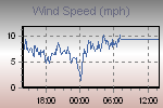
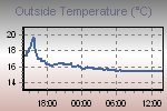
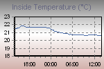
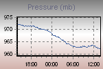
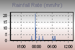
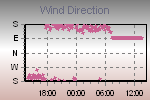
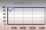
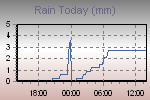
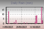
These graphs present the temperature, pressure, rainfall, and wind speed trends for the last 24 hours.
The thumbnail graphs are sampled every ten minutes. Click on a thumbnail to display the corresponding larger graph in the panel above it. The large graphs are sampled every minute.

| Click on a thumbnail to show a large graph in the panel above. | |||||
 |
 |
 |
 |
 |
|
 |
 |
 |
 |
 |
|
|
|||||
Page updated 20/10/2023 14:00:00
powered by
Cumulus v1.9.4 (1099)